--!
--!
How the Alfred Wegener Institute used Cathx Ocean’s subsea camera, lighting and software to track year-on-year changes to the abyssal seafloor and fauna, and investigate spatial population density in The Fram Strait
CASE STUDY
THE ALFRED WEGENER INSTITUTE
Working with The Alfred Wegener Institute, we demonstrated how Cathx Ocean systems can eradicate the challenges associated with seafloor surveys including poor visibility, slow survey times, accurate geolocation, measuring changes in the fauna and seafloor over time, and investigating spatial population density.
Client
The Objectives
Surveying of the abyssal seafloor area year-on-year to see changes in the fauna and abyssal seafloor over time.
To investigate the spatial population density in The Fram Strait.
Overcome poor visibility and slow survey times when conducting seafloor surveys, to provide high quality image data.
The Client
The Alfred Wegener Institute (AWI) is an internationally respected centre of expertise in polar and marine research. It conducts research in cold and temperate regions of the world in the Arctic, the Antarctic, high and mid latitude oceans.
The Alfred Wegener Institute explores the earth’s system from the atmosphere to the ocean floor. Initiatives to better understand the central roles played by the polar regions and oceans in climate change are of increasing importance.
The Alfred Wegener Institute is located at Helmholtz Centre for Environmental Research in Bremerhaven, Germany. It was founded in 1980.
SYSTEM CONFIGURATION
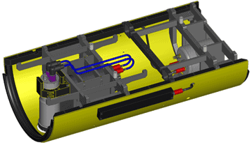
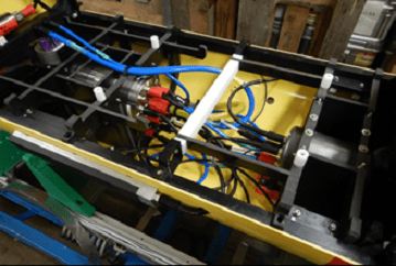
- A Cathx Fast Fly Stills Camera
- Two Cathx Pulsar I Strobe Lighting Systems
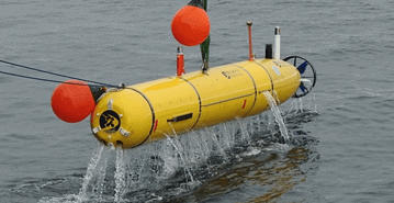
- Integrated into the Bluefin-21 AUV
- Cathx Mission Planner Software
- SOLID Post Processing Image software
THE CHALLENGES
Sufficient technology was not available to annually capture the same area of the abyssal seafloor to monitor year-on-year changes to fauna and the seafloor.
A spatial population investigation had never previously been completed in The Fram Strait.
The Alfred Wegener Institute carry out surveys of the seafloor using a towed underwater vehicle at FRAM stations. These surveys were reliant on ship motion. They previously only provided thin tracks of data, allowing for a ribbon of 2 meters wide of images to be collected over several kilometres. Issues such as lack of sufficient light, motion blur and particle back scatter can severely reduce the quality of the images collected. It also takes more time to survey the area leading to longer vessel time and higher operating costs.
THE SOLUTION
The Alfred Wegener Institute required an imaging system that integrated into their Bluefin-21 AUV, which provides quality images and geolocation data of the abyssal seafloor under the polar ice. Accurate data is required to track year-year changes to fauna and the seafloor, and to conduct a spatial population investigation in The Fram Strait.
The Cathx Fast Fly Camera and Pulsar Strobe Lighting system was incorporated, which was easily mounted onto the AUV.
The Fast Fly Camera and Pulsar Strobe Light system was specially designed to deliver high quality clear high-resolution images.
It is a robust system that allows the vehicle to be flown in proximity to the seafloor for an improved dive plan, allowing for a more extensive area to be photographed in a similar amount of time.
The navigation and GPS information are stored in the image EXIF by the camera which allows for the same area of the seafloor to be covered year-on-year. This will enable for both spatial and temporal analysis of the data. The Alfred Wegener Institute will now be able to build a profile of the ecosystem and monitor trends over time. Relationships between the fauna and features on the seafloor such as dropstones, phytodetritus accumulations and litter can now be accurately determined.
THE RESULTS
The results speak for themselves.
HIGHER QUALITY IMAGES WITH EXTENDED RANGE
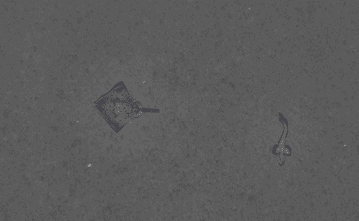
The Cathx Fast Fly camera system delivered high quality, clear images at Ultra High (UHD) resolutions of below one millimeter.
The Pulsar Strobe light draws a constant low power draw on the vehicles power source. It stores the energy and releases it in a 150,000 Lumen strobe of light when the camera takes an image at frame rates up to 7 images per second. This allows users to extend the range of the underwater vehicle.
Using the Pulsar Strobe lighting with the Cathx Fast Fly Camera reduces motion blur and backscatter. It allows the vehicle to travel at higher speeds than with conventional Video Systems. To ensure all images captured by the Fast Fly stills camera are sharp and clear, it has the ability to adjust its focus according to inputs from the vehicle depth sensors.
The high-quality imaging permits accurately mapping the abyssal seafloor, and investigating the spatial population density in The Fram Strait.
IMPROVED DATA OUTPUTS FOR YEAR-ON-YEAR COMPARISONS
The Fast Fly Imaging system captures sequential image data that is time stamped and geo-tagged. This facilitates post data processing to assemble mosaics, and this data is also compatible with third party inspection software.
Data can be written directly to the vehicle data storage NAS drive.
This allows for accurate year-on-year comparisons to see changes in the fauna and abyssal seafloor over time.
REDUCED VESSEL TIME AND CO2 EMMISSIONS
The time taken to acquire the images was considerably quicker saving vessel time, resources and co2 emissions. The vehicle can be flown within 5 meters of the seabed and at operational speeds of 4 knots. This also allows for a more extensive area of the seabed to be surveyed.
IMPROVED MISSION PLANNING
The Cathx Mission Planner Software is used pre-mission to set up the Fast fly imaging system for the mission ahead by setting up a profile that the imaging system can activate in real-time on mission via the Camera API.